Photos: Before and after satellite photos of the Bay Area after string of atmospheric rivers

California satellite photo (NASA).

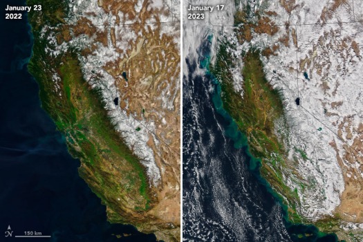
The wettest three-week period the Bay Area has seen in more than 160 years has brought a medley of colors to the region as seen from space. A series of atmospheric rivers have left behind white snow-capped mountains to teal coastal waters created by runoff from overflowing waterways.

Bay Area as seen from NASA’s Aqua satellite. (NASA) 

The natural-color images were taken by the Moderate Resolution Imaging Spectroradiometer (MODIS) on NASA’s Aqua satellite. NASA’s Earth Observatory compared images taken from Jan. 23, 2022 and Jan. 17, 2023.

When the soil is saturated, water flows into nearby waterways often taking sediment with it  and creating

→ Continue reading at Mercury News

More from author

Related posts

Advertisment

Latest posts

OpenAI officially announces Sam Altman has returned as CEO | CNN Business

New York CNN  —  Twelve days after OpenAI fired Sam Altman as CEO, the company formally announced that it...

Watch: Elon Musk lashes out at advertisers for pulling their ads off of X | CNN Business

Elon Musk lashes out at advertisers for pulling their ads off of X ...

UAW aims to organize 13 nonunion automakers | CNN Business

New York CNN  —  The United Auto Workers union says it has started an effort to organize workers at...